May 18, 2022
Colorado River – May 2022 Update
The fact that we live in a harsh desert environment is being impressed upon us rather vigorously after more than two decades of severe drought. Climatologists have marked the current drought as a megadrought and the worst experienced in the desert Southwest in more than 1,200 years. We are living in unprecedented times in terms of water shortages on the Colorado River watershed and system (Figure 1) along with increasing demand for water from this river over the past several decades which is depleting the two giant reservoirs, Lakes Mead and Powell. These conditions have resulted in the 2021 declaration by the U.S. Department of the Interior (DoI) and Bureau of Reclamation (BoR) for reductions in allocations from the Colorado River with Tier 1 restrictions associated with the Drought Contingency Plan (DCP, Table 1).

Figure 1. The Colorado River watershed that includes seven western U.S. states and 2
Mexican states, supports >40M people, >5.5M acres of farmland, and 22 Native American
tribes. Source: USGS.

Table 1. Drought Contingency Plan reductions in Arizona’s allocation from the Colorado River.
FAS = feet above sea level; KAF = thousand acre-feet; MAF = million acre-feet
According to the DCP, Tier 1 requires a 512,000 acre-foot (AF) reduction in Arizona’s 2.8MAF annual allocation. This reduction is primarily being taken from the agricultural irrigation districts associated with the Central Arizona Project (CAP), heavily impacting agricultural areas in Pinal County. It is important to note that urban/metropolitan and tribal water allocations are not reduced in Tier 1 conditions (Figures 1 and 2). In response to the drought and the declining water supply in the Colorado River system, additional mitigation actions are being taken beyond the DCP reductions to further support the level of water in these storage reservoirs which have been steadily declining since 2000.
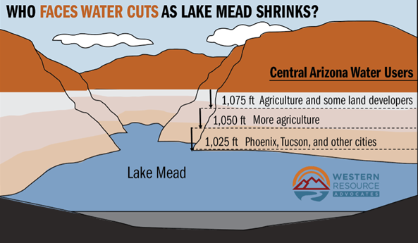
Figure 2. General outline of reductions in water allocations by general source associated
with the Drought Contingency Plan.
The situation on the Colorado River system and the responses have been changing rapidly. On 3 May 2022 we learned that the BoR is holding back 480KAF from Lake Powell from the originally planned 7.48MAF release in fiscal year 2022. Also, the BoR is also releasing an additional 500KAF from the Flaming Gorge reservoir on the Wyoming – Utah border. Both steps are being taken to protect the hydroelectric power generation capacity of the Glen Canyon Dam (Lake Powell). If the lake falls to 3,490 ft. above sea level (FAS) at Glen Canyon Dam there would not be enough water to operate the generators in Glen Canyon Dam that provides power to the western electrical grid and serves as a primary source of electrical power to Wyoming, Utah, Colorado, New Mexico, Arizona, Nevada, and Nebraska. This is due to the placement of the penstocks that were built into the dam that provide water to the electrical generation turbines. If the water level were to drop below the 3,490 FAS level it could cause cavitation and severe damage to the electrical turbines and the dam structure. The nearly 1MAF of extra water being held in Lake Powell behind the Glen Canyon Dam is intended to protect the electrical power generation and integrity of the dam.
So, this translates to nearly 480KAF less water moving through the Grand Canyon and into Lake Mead in FY22 and it puts the lower basin (the region below Lake Powell, Figure 1) one step closer to Tier 2 reductions.
The BoR periodically runs a series of model projections regarding the water levels at the dams for both Lakes Mead and Powell. Results from these models recently projected future water levels at the dams for the end of calendar year (CY) 2022 and 2023. For Lake Mead the end of CY 2022 projections include a most probable level of 1,049.37 FAS and the lowest probable level at 1,047.10 FAS. These results project the need for a Tier 2a level declaration by the end of CY 2022.
For the end of 2023, Lake Mead projections include a most probable level 1,035.63 FAS, which would trigger Tier 2b reductions in Colorado River water allocations to Arizona and a most probable minimum level of 1,020.63 FAS, which would necessitate Tier 3 reductions.
Due to the recent changes in river management plans that have been announced by the BoR associated with Lake Powell, these model projections for the end of CY 2022 and 2023 are probably high and probably project an overly optimistic condition. But we can see that the probability of moving into the Tier 2a, 2b, and Tier 3 reductions are very likely to occur by the end of 2023, if not sooner.
The warnings of John Wesley Powell, the famous one-armed Civil War Veteran who first directed an expedition down the Colorado River and the Grand Canyon in 1869, are certainly very prescient in the face of the circumstances we are dealing with today. In an address to the Montana Congressional Convention in 1889 he offered the following statement: “All the great values of this territory have ultimately to be measured to you in acre feet”. That is incredibly prophetic and certainly true in the reality of conditions that we are dealing with on the Colorado River today.
Essentially what we have today on the Colorado River is a supply and demand problem. Very simply, our demand and extractions from the Colorado River have been greater than the supply and what the river can provide. As a result, the great reservoirs on the river system, the savings accounts so to speak, have been depleted. We must come to grips with that reality and decide how the allocations of Colorado River water must be adjusted to bring them into an appropriate balance with the water we do have in the river.
The overall situation with the Colorado River offers some good news and some bad news for all of us depending on this water to live, work, and survive in this desert. The average annual flow of the Colorado River between 2000 and 2018 has been approximately 12.4MAF, which is 16 % lower than the 1906-2017 average of 14.8MAF/year. So, the good news is with the recognition that we have ~ 12MAF average annual flow in the Colorado River under these megadrought conditions. The bad news is that the Colorado River system is budgeted for 16.5MAF of allocated water between the U.S. and Mexico. Thus, there is a functional difference of >4MAF and the fact is that we must reconcile that difference and fast action is needed, much faster than our water governance systems normally operate.
Arizona agricultural is responsible for ~ 70% of the water diversions on the Colorado River and agriculture is taking the reductions now with Tier 1 and will carry much of the responsibility for the Tier 2 reductions. How agriculture fares in this process of Colorado River management in response to the water shortages is critical for the future of Arizona agriculture and the overall complexion of life in the desert Southwest.
I believe agriculture will prevail, but a lot of hard work, difficult decisions, and changes are ahead of us in the near future. Agriculture has some strong and effective groups working in this decision-making arena for water governance on the Colorado River and we need to be sure that practical agricultural considerations are being made in the process with both short and long-term implications.
 To contact John Palumbo go to: jpalumbo@ag.Arizona.edu


