Arizona consistently produces the highest yields and quality of crops found anywhere. This is a testimony to not only the skill of Arizona farmers and the capacity to irrigate and produce crops in the desert but also to the productive soils that we are fortunate to have in this region. Soils are commonly considered to serve as the foundation of agriculture (Parikh and James, 2012) and that is certainly true in Arizona.
Many people think Arizona is composed of nothing but rocks and sand. While we do have an abundance of rocks and sand in Arizona, this region also has many areas with soils that are geologically young, with high natural fertility, and extremely productive if provided with sufficient water and good management.
Most Arizona crops are produced on alluvial soils that are formed from the deposits of sediments from periodic flooding of rivers and streams over thousands and millions of years. The alluvial soils used in Arizona crop production vary tremendously across the state and the entire desert Southwest. They vary in texture, depth, and structure. Our crop production capacities in this region are supported by the irrigation water and these incredible soil resources.
A great example of the rich alluvial soils of this region can be found in the lower Colorado River valleys including Mohave Valley, AZ; Parker Valley, AZ; Palo Verde Valley, CA; Imperial Valley, CA; Bard Valley, CA; Yuma Valley, Arizona; and the lower Gila Valleys of Arizona. The alluvial sediments that have formed the soils we encounter in the lower Colorado River system are estimated to have been deposited to several hundred meters (several thousand feet) in depth in the current river channel approximately 4.63 to 4.80 million years ago (Crow et al., 2021 and Kimbrough et al., 2015). These sediments are geologically “young” in contrast to the ancient crystalline rocks at the bottom of the Grand Canyon, often referred to as the “Vishnu Basement Rocks” that are 1,680 – 1,750 Ma (1.68 – 1.75 billion (b) years ago), (Crow, et al., 2021 and Mathis and Bowman, 2018).
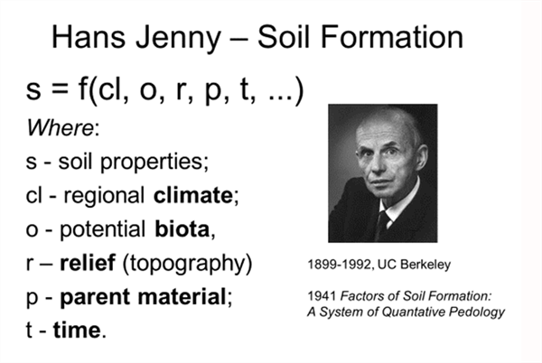
In 1941, Dr. Hans Jenny from the University of California – Berkeley, published Factors of Soil Formation: A System of Quantitative Pedology. [Pedology is the scientific study of soils and their weathering profiles, including the formation, nature, ecology, and classification of soil.] This book is a classic and fundamental piece of work in the study of soil science due to Jenny’s capacity to translate the basic concepts into a quantitative scientific framework through a rigorous definition of the soil system and its genesis, including the identification and separation of dependent and independent variables.
Jenny described soil formation as a function of five factors: climate, biota (plants and animals), relief (topography), and parent material, all operating together over time (Figure 1).
Alluvial soils tend to be highly variable both horizontally across the landscape and vertically down through the soil profile. This can sometimes present challenges in field-level management for crop production, particularly when soil types change within a given field or relatively small area, which is rather common.

Figure 1. Hans Jenny and the factors of soil formation, 1941.
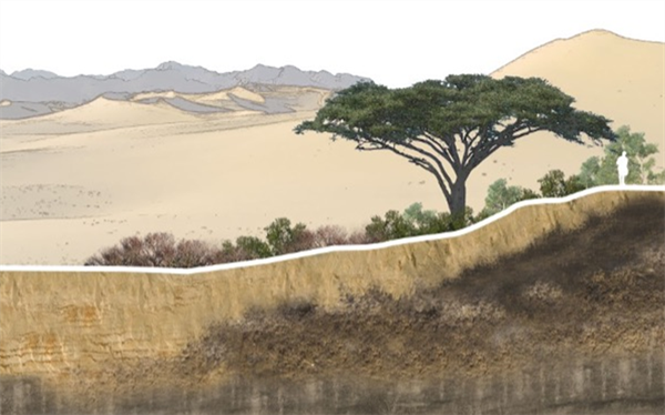
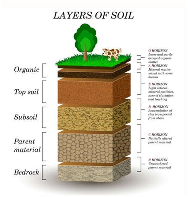
We commonly find that soil formation will vary tremendously across a landscape with natural soil variation across the landscape in both the horizontal and vertical dimensions with the distinct organization of soil horizons (Figures 2 and 3).
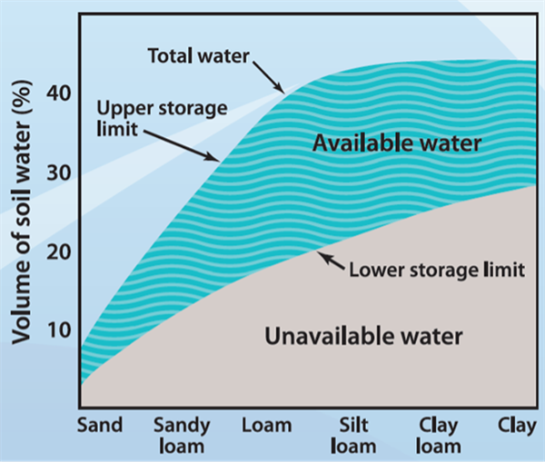
It is important to recognize soil variability in a crop production system because different soil types will have unique physical and chemical properties that can affect things like soil-water holding capacity, drainage, leaching capacities, soil fertility, and plant root development.
The United States Department of Agriculture (USDA) Natural Resources Conservation Service (NRCS) has conducted extensive soil surveys across the United States for each state by county. Soil surveys can be accessed on-line at the following site: https://websoilsurvey.nrcs.usda.gov/app/
A broad map selected from NRCS Soil Survey of the Yuma area graphically depicts both the alluvial nature and variability of the soil resources commonly encountered in this area. https://websoilsurvey.nrcs.usda.gov/app/WebSoilSurvey.aspx
It is important to recognize the importance and high value of these natural soil resources that our agricultural systems are developed and dependent upon and be alert to the natural variability associated with the alluvial soils in this region.

Figure 2. Natural variation of soils across a landscape

Figure 3. Layers of soil, basic organization of soil horizons.

Figure 4. Soil volume, soil texture, and water holding capacity
relationships. Source: Kansas State University Agronomy Department, Soil
Laboratory Manual.
References:
Crow, R.S., J. Schwing, K.E. Karlstrom, M. Heizler, P.A. Pearthree, P.K. House, S. Dulin, S.U. Jänecke, M. Stelten, and L.J. Crossey. 2021. Redefining the age of the lower Colorado River, southwestern United States: Geology, v. 49, p. 635–640, https://doi.org/10.1130/G48080.1
Jenny, H. 1941. Factors of Soil Formation: A System of Quantitative Pedology. McGraw-Hill Book Company. New York and London.
https://netedu.xauat.edu.cn/sykc/hjx/content/ckzl/6/2.pdf
Kimbrough, D.L., M. Grove, M., G.E. Gehrels,, R.J. Dorsey, K.A. Howard, O. Lovera, A. Aslan, P.K. House, and P.A. Pearthree. 2015. Detrital zircon U-Pb provenance of the Colorado River: A 5 m.y. record of incision into cover strata overlying the Colorado Plateau and adjacent regions:
Geosphere, v. 11, p. 1719–1748, https://doi.
org/10.1130/GES00982.1.
Kansas State University Agronomy Department, Soil Laboratory Manual: Soil and water relationships. https://kstatelibraries.pressbooks.pub/soilslabmanual/chapter/soil-and-water-relationships/
Mathis, A. and C. Bowman. 2018. Telling Time at Grand Canyon National Park. United States Department of the Interior, National Park Service.
Parikh, S. J. and B.R. James. 2012. Soil: The Foundation of Agriculture. Nature Education Knowledge 3(10):2
https://www.nature.com/scitable/knowledge/library/soil-the-foundation-of-agriculture-84224268/#
This study was conducted at the Yuma Valley Agricultural Center. The soil was a silty clay loam (7-56-37 sand-silt-clay, pH 7.2, O.M. 0.7%). Spinach ‘Meerkat’ was seeded, then sprinkler-irrigated to germinate seed Jan 13, 2025 on beds with 84 in. between bed centers and containing 30 lines of seed per bed. All irrigation water was supplied by sprinkler irrigation. Treatments were replicated four times in a randomized complete block design. Replicate plots consisted of 15 ft lengths of bed separated by 3 ft lengths of nontreated bed. Treatments were applied with a CO2 backpack sprayer that delivered 50 gal/acre at 40 psi to flat-fan nozzles.

Downy mildew (caused by Peronospora farinosa f. sp. spinaciae)was first observed in plots on Mar 5 and final reading was taken on March 6 and March 7, 2025. Spray date for each treatments are listed in excel file with the results.
Disease severity was recorded by determining the percentage of infected leaves present within three 1-ft2areas within each of the four replicate plots per treatment. The number of spinach leaves in a 1-ft2area of bed was approximately 144. The percentage were then changed to 1-10scale, with 1 being 10% infection and 10 being 100% infection.
The data (found in the accompanying Excel file) illustrate the degree of disease reduction obtained by applications of the various tested fungicides. Products that provided most effective control against the disease include Orondis ultra, Zampro, Stargus, Cevya, Eject .Please see table for other treatments with significant disease suppression/control. No phytotoxicity was observed in any of the treatments in this trial.
Fig. 1. Finger weeders removing a large, in-row Palmer Amaranth plant in cotton – slow motion video. (Video credit: Kyle R. Russel, Texas A&M University. Cultivator design and setup credit: Carl Pepper, Lubbock, TX). Click here or on the image to see the video.
We have recently received winter grass samples for identification and one of the most common has been Annual Bluegrass (Poa annua). Native to Europe it is distributed worldwide we find it invading homeowner landscapes, golf courses, and agricultural fields. It reproduces only by seeds1 and can have several generations per year. The leaf blades are about 3 in long and plants are about 4 to12 inches tall. The flowering part is about 1to 4 inches long There are several species of the genus Poa but we included in this article the most typical characteristics of the Poa annuaspecies3.
Please check the highlighted features of this grass in the illustrations below:
When leaves are looked through light two transparent lines on both sides of the midrib can be seen 2

Figure1. Key characteristics of annual bluegrass. (Images: M. Peña and Jim
Converse Proturf Guide to the Identification of grasses).

Figure 2. Proturf Guide to The Identification of Grasses, Jim Converse
References:
Results of pheromone and sticky trap catches can be viewed here.
Corn earworm: CEW moth counts down in all traps over the last month; about average for December.
Beet armyworm: Moth trap counts decreased in all areas in the last 2 weeks but appear to remain active in some areas, and average for this time of the year.
Cabbage looper: Moths increased in the past 2 weeks, and average for this time of the season.
Diamondback moth: Adults increased in several locations last, particularly in the Yuma Valley most traps. Below average for December.
Whitefly: Adult movement remains low in all areas, consistent with previous years
Thrips: Thrips adult movement continues to decline, overall activity below average for December.
Aphids: Winged aphids still actively moving but declined movement in the last 2 weeks. About average for December.
Leafminers: Adult activity down in most locations, below average for this time of season.